

Ahora estás siguiendo a
Error al seguir a usuario.
Este usuario no permite que los usuarios lo sigan.
Ya estás siguiendo a este usuario.
Tu plan de membresía solo permite 0 seguimientos. Mejora tu membresía aquí.
Dejaste de seguir correctamente a
Error al dejar de seguir al usuario.
Has recomendado exitosamente a
Error al recomendar al usuario.
Algo salió mal. Por favor, actualiza la página e intenta de nuevo.
Email verificado correctamente.

riyadh,
pakistan
Aquí son las 8:50 a. m.
Se unió el enero 17, 2013
1
Recomendación
Adnan R.
@adnanrauf143
0,7
0,7
100%
100%
riyadh,
pakistan
50 %
Trabajos finalizados
100 %
Dentro del presupuesto
100 %
A tiempo
N/A
Tasa de recontratación
GIS / Remote Sensing Trainer and Expert
Contacta Adnan R. sobre tu trabajo
Inicia sesión para comentar cualquier detalle por chat.
Portafolio
Portafolio
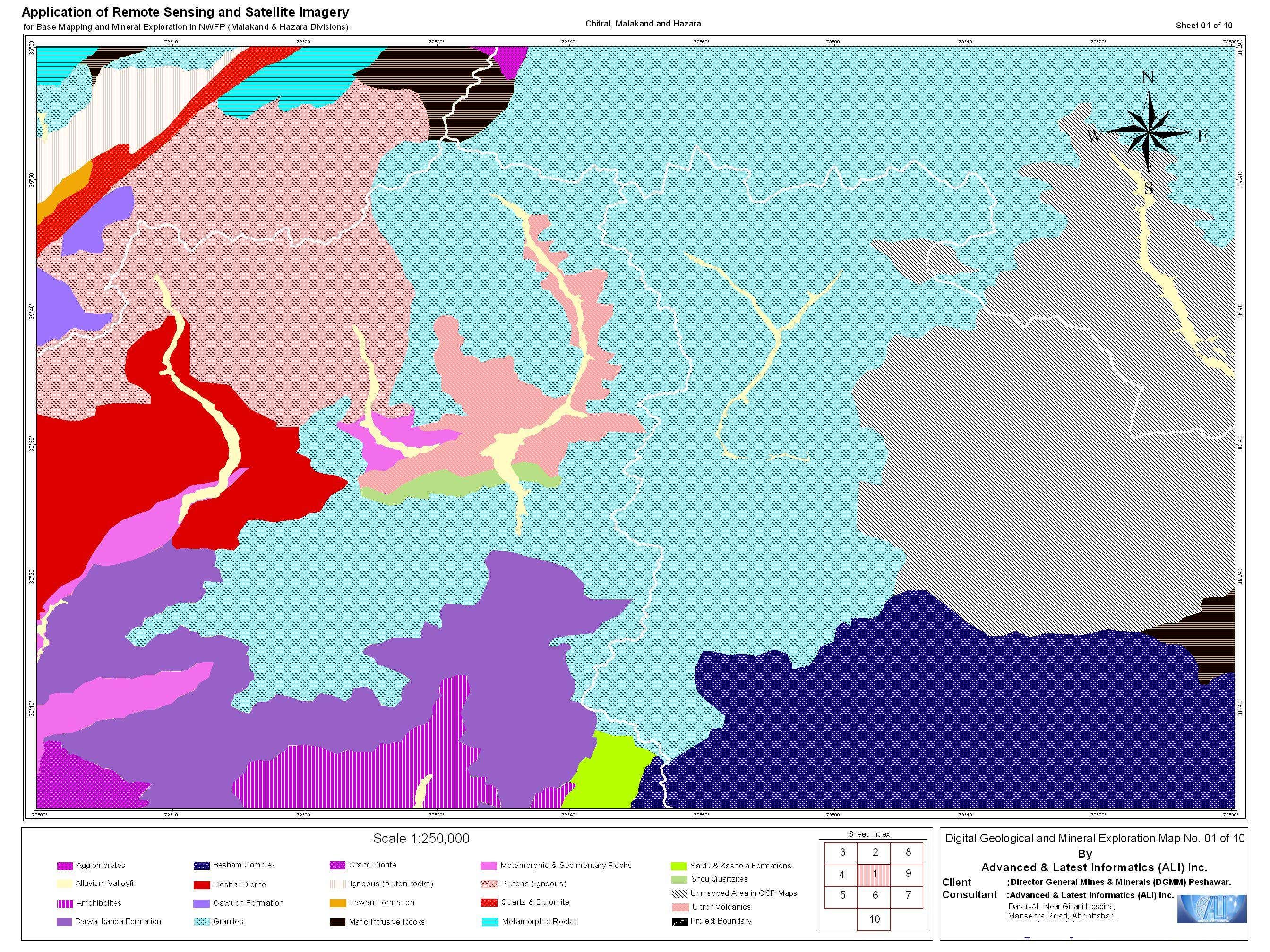

1:250k Mapsheept for a Geological Base mapping project
Geostatistical Techniques fto predict Bird specie Occurences
1:250k Mapsheept for a Geological Base mapping project
Geostatistical Techniques fto predict Bird specie Occurences
Comentarios
Cambios guardados
Mostrando 1 - 2 de 2 reseñas
$108,80 USD
Report Writing
Research Writing

•
$35,00 AUD
Research Writing
T
•
Experiencia
GIS Analyst
may 2012 - Presente
Working on a Project aimed to study Effects of Light pollution for Singapore. Defense Metereological Statellite Program (DMSP) data is used to model the Light pollution
Teaching Assitant
ene 2011 - mar 2011 (2 meses, 1 día)
Worked as teaching assistant for a course titled "AG2414 Spatial Analysis" in International Masters Program Geodesy and Geoinformatics. My responsibilities included:
o Conducting the labs and helping students in any technical problems with GIS software's used in GIS Lab
o Preparing new lab exercises as per guidelines and regulations of Geoinformatics Department
GIS / Remote Sensing Specialist
ene 2006 - dic 2006 (11 meses, 1 día)
Worked as Assistant GIS / Remote Sensing Specialist with Advanced and Latest Informatics (ALI) Inc. (ALI Inc. is an US based company having its offices in USA, Canada, Russia, and Pakistan). My responsibilities included:
o Processing Satellite Imagery of Landsat 7 (ETM+) and carry out image processing and conduct mosaicking, geo-referencing, color enhancements, coordinate and projection conversions
o Digitizing to convert paper maps into digital GIS maps and developing GIS maps for final printing purp
Educación
International Masters in Geodesy & Geoinformatics
(4 años)
Masters in Computer Sciences from Comsats Institute of Information Technology
(2 años)
Calificaciones
Introduction to ArcGIS Server
ESRI Sweden
2008
A two day Course from ESRI packed with morning, evening sessions to enhance skill of the GIS students for using ARCGIS Server Technology.
Publicaciones
"Geostatistical Techniques for Predicting Bird Specie Occurences"
DIVA KTH
Reserach not exactly Publication was carried out as Masters Thesis in Royal Institute of Technology, Stockholm Sweden. It involved using Geostatistical Techniques of Kriging and Logistic Regression to model Bird specie Prediction. Abstract of the study is attached in my Profile portfolio.
Contacta Adnan R. sobre tu trabajo
Inicia sesión para comentar cualquier detalle por chat.
Verificaciones
Principales habilidades
Explorar freelancers similares
Explorar galerías similares
¡Invitación enviada correctamente!
¡Gracias! Te hemos enviado un enlace para reclamar tu crédito gratuito.
Algo salió mal al enviar tu correo electrónico. Por favor, intenta de nuevo.
Falló el copiado al portapapeles. Intenta de nuevo después de ajustar tus permisos.
Copiado al portapapeles.
Cargando visualización previa
Permiso concedido para Geolocalización.
Tu sesión de acceso ha expirado y has sido desconectado. Por favor, inica sesión nuevamente.